2020
MARCH
March 7th – El Escorpion Park, Cave of Munits, and Castle Peak
[Best_Wordpress_Gallery id=”293″]
15 hikers met at the El Escorpion Park entrance (905’) at the west end of Vanowen Street in the San Fernando Valley on a cool partially overcast late-winter morning. We began our hike into the Simi Hills along the Hunter Allen Trail (aka Moore Canyon Road), a wide dirt road with no shade, but soon turned right/north on a “use” trail which led down to a heavily shaded “use” trail that led us westward parallel to (but out of sight of) the dirt road. We eventually reached the well-defined “use” trail leading north up to the entrance to the Cave of Munits.
show more
After regrouping, we headed southward down to the Hunter Allen Trail and followed it westward a short distance until it turned southward. At that point we continued westward along a trail/dirt road which we followed to another “use” trail that led us mostly northward past several oak trees and then steeply up a north-south ridge to the main east-west ridge (with Castle Peak at its east end). Our climb was aided by the mild temperature and occasional clouds; the trail was bordered by lots of blooming plants. Once up on the east-west ridge, we followed a mostly well-defined single track trail east to Castle Peak until it ended about 20′ from the top of the peak. Along the way we were treated to wide views of the surrounding area as well as interesting rock formations. Most members of our group climbed up to the top of Castle Peak (1,475’). After resting for a while, we returned the way we came (passing by the Cave of Munits turnoff) and reached our vehicles having hiked 4.8 miles with a little over 1,200’ of elevation gain/loss. NOTE: The blooming plants we saw were most notably fiddleneck, bush sunflowers, and morning glories as well as blue dick, prickly phlox, datura, and lupine.
show less
FEBRUARY
February 29th – Happy Camp Canyon and Middle Range Fire Road Loop
[Best_Wordpress_Gallery id=”291″]
23 hikers met in the dirt parking lot at the east end of Broadway Road north of Moorpark on a sunny morning with a pretty blue and white-cloud-dotted sky. After a group photo was taken, we followed a well-maintained trail beside the Rustic Canyon golf course a little over a mile to the entrance to Happy Camp Canyon, “a lush riparian oak woodland with an intermittent stream,” enjoying a lovely display of lush green grass and wildflowers including Fiddleneck, Purple Nightshade, Collar and Bush Lupine, Bush Sunflowers, Blue Dick, Bladerpod, California Peony, Wishbone, Datura, Prickly Phlox, Owl’s Clover and California poppies.
show more
We then split into two groups; one group returned to the parking lot the way we had come; the other group climbed steeply for 0.5 mile up Big Mountain to the Middle Range Fire Road via an abandoned, steep, and partially eroded dirt connector road. Once we reached the ridge (and recovered from the steep climb) we took in the views to the south and west which were relatively clear for several miles, but were hazy at greater distances (for example, we couldn’t see any of the Channel Islands). After hiking westward while enjoying blooming plants including large swatches of Fiddleneck, California poppies, and some beautiful Collar and Bush Lupine as we descended to the entrance to Happy Camp Canyon, we made our way back to the parking lot. The group that chose to hike the loop completed an 11-mile hike with 1,543′ of elevation gain/loss. The group that chose the out-and-back option completed a 9.8-mile mile with 985′ of elevation gain/loss. It was indeed a very nice day for hiking.
show less
February 22nd – Danielson Memorial via the Fossil Trail
[Best_Wordpress_Gallery id=”289″]
13 hikers gathered at the Wendy Trail trailhead at the south end of Wendy Drive in Newbury Park on a cool midwinter morning with a blue sky that was partially filled with towering clouds that suggested the possibility of rain. Our Santa Monica Mountains outing began as we hiked the Wendy Trail over to the Satwiwa Native American Indian Culture Center in Rancho Sierra Vista. We then headed south as the paved upper section of Sycamore Canyon Road descended into the canyon; as we did so we passed large areas covered with lush green grass.
show more
When we reached the junction with the Boney Mountain Trail, we took a break and then turned left and continued on up the mountain with excellent views to the west and after a while to the north and east. We encountered bush sunflowers, California poppies, and morning glories along the way. When we reached the junction with Danielson Road, we turned right and hiked the short distance to the Danielson Memorial and the ruins of the Danielson house (only a chimney remains) where we took a lengthy break in the still heavily wooded (unburned) area. As we continued our hike we descended along the Danielson Road and visited the usually dry waterfall along the way. Fortunately there was a little water flowing in the stream so we saw a small waterfall. A few minutes later we followed the Windmill Trail (where we encountered a lovely display of shooting stars) back to the parking area which we reached having completed an 8.1-mile loop hike with about 2,000’ of elevation gain/loss (without being rained on) on another great morning for hiking.
show less
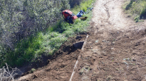
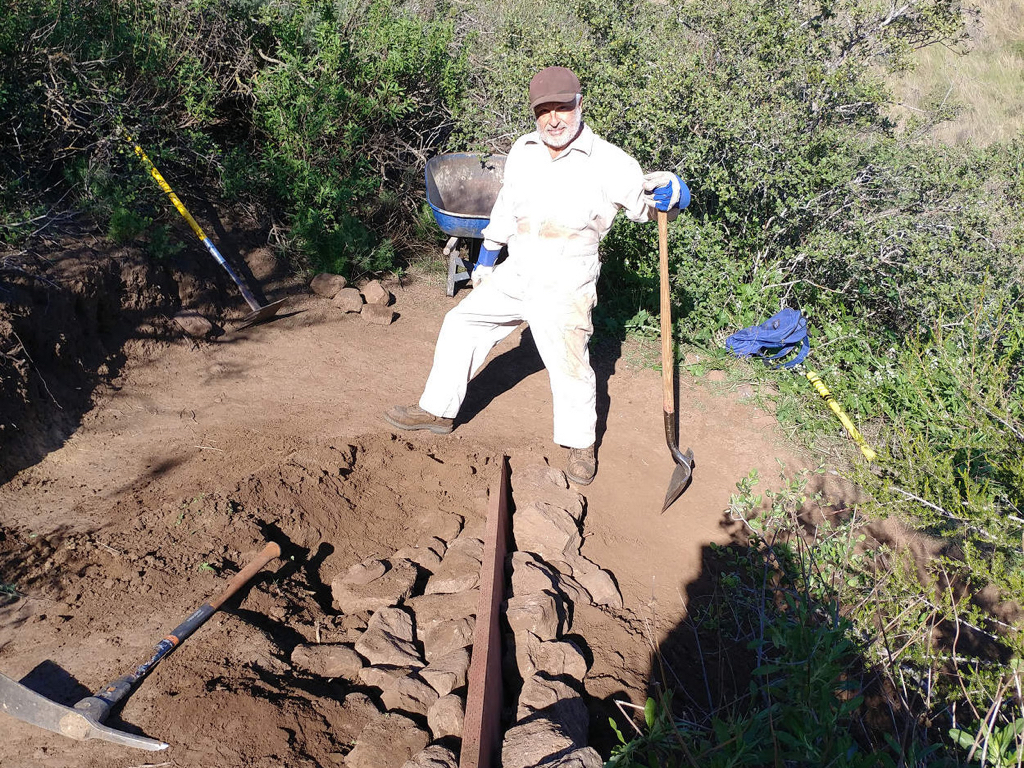
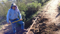
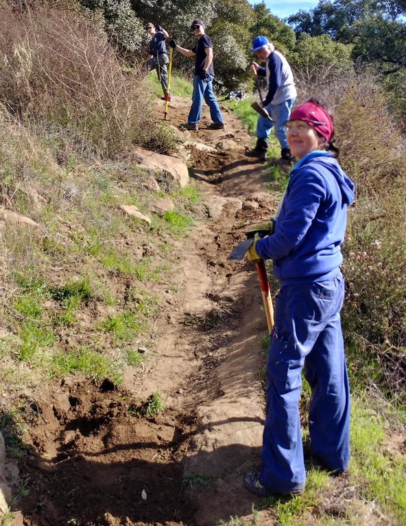
February 15th – Work Party – Mt. McCoy trail
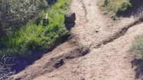
The February Trail Blazers trail work party was held on the Mt. McCoy trail.
Work was conducted in 3 areas. The first area was at a steep sharp turn in the trail that had been rebuilt with rock on two previous work parties and both times were collapsed by hikers short cutting the turn. This time we installed an 8 foot section of 2 x 8 board. The board was backed up on both sides by rock and then covered with dirt. Brush was trimmed on the turn as well, to encourage hikers to stay on the trail.
show more
Working down trail, the next two areas consisted of fixing sections of steep downhill trail side slopes caused by erosion from rain water runoff from illegal trail cutting paths perpendicular to the trail. Again we installed 8 foot 2 x 8 boards at both locations and leveled the trail with dirt fill.
We worked from 8:00 AM to Noon. On our way out, we also removed some of the cacti growing out into the trail path where the trail passes through the edge of a giant patch of Prickly Pear Cactus at the bottom of the trail.
Work was conducted by Martin DeGoey and John Sabol. A special thanks to Martin who on the week before had purchased and hauled up the three 8 foot 2 x 8 boards and hid them in the brush near the work locations.
show less
February 8th – Solstice Canyon
[Best_Wordpress_Gallery id=”287″]
14 hikers carpooled to Solstice Canyon in the Santa Monica Mountains National Recreation Area near the Pacific Ocean on a cool mid-winter morning. Our out-and-back hike began by following flowing Solstice Creek along the nearly-level, well-shaded Solstice Canyon Trail (a dirt road), taking advantage of two short trails paralleling the dirt road along the way, and reaching the Sostomo Trail junction after about one mile.
show more
After reaching Deer Valley, we followed the loop trail in a clockwise direction as it ascended the mountainside to an overlook of the Pacific Ocean. There were good views of the surrounding land area, but ocean views were limited. We spotted a couple of patches of blooming California poppies near the overlook point, adding to the spring-like feeling of the day. After taking a break we completed the loop and then returned along the Sostomo Trail to the Solstice Canyon Trail (road).
Turning left we walked the very short distance to Tropical Terrace, the ruins of the Roberts house built in the 1950s and destroyed by wildfire in 1982. At one time there were giraffes, camels, buffalo, African deer, and exotic birds in the canyon (but not now!). We took a lengthy lunch/rest break at Tropical Terrace and enjoyed the ambiance of palm trees, murmuring Solstice Creek, and water in the nearby waterfall. We then returned to our vehicles via the Solstice Canyon Trail having completed a 7-mile hike with about 1,700’ of elevation gain/loss.
show less
February 1st – Temescal Gateway Park
[Best_Wordpress_Gallery id=”285″]
13 hikers carpooled via Hwy 118, I-405, and Sunset Blvd to the lower parking lot at Temescal Gateway Park in Pacific Palisades on a beautiful morning for hiking. A lovely refuge from the nearby urban congestion, the park borders Topanga State Park. Our hike began on a shady trail along the streambed in Temescal Canyon and led pleasantly past rustic buildings constructed in the 1920’s for the Methodist Church as a west coast center for the Chautauqua movement.
show more
The trail began rising (as did the temperature) in Temescal Canyon as it entered Topanga State Park and we soon reached a wooden bridge crossing the (barely-existent-today) stream at a point where there is sometimes a series of cascades (a “waterfall”) though they contained almost no water due a recent lack of rain. Continuing westward along the trail as the temperature continued to climb, we soon reached Temescal Ridge and were rewarded by panoramic views of the Santa Monica Mountains, the coastline, and the Los Angeles skyline. Since the temperature was well on its way to being uncomfortable, we quickly descended along the Temescal Ridge (aka Viewpoint) Trail to the canyon bottom where we took advantage of the nice bathroom facilities, having abandoned the planned continuation of the hike over to Will Rogers State Historic Park. We returned to Simi Valley having completed a 4.2-mile hike with 1,025’ of elevation gain.
show less
JANUARY
January 25th – Griffith Park: Ferndell Park to Mt. Hollywood and Mt. Lee
[Best_Wordpress_Gallery id=”283″]
10 hikers carpooled to the Ferndell area (600’) near the southwest corner of Griffith Park on a cool winter morning. Our hike began on a well-shaded trail dominated by large oak and sycamore trees, but soon began climbing northward on the busy East Observatory Trail (a dirt fire road), reaching the Griffith Park Observatory (1,131’) in a mile or so.
show more
After taking a break, we headed north and then west (passing near Mt. Bell and Mt. Chapel) via a combination of dirt fire roads and a couple of deserted narrow single-track trails toward Mt. Lee (1,680’), the “home” of the famous Hollywood sign. However, shortly after we started hiking on the second single-track trail we reached a short nearly vertical climb which at least one member of our group couldn’t climb. As a result we decided to skip going to Mt. Lee and backtracked to Mt. Hollywood Drive and then followed it and the West Trail back to our vehicles. We then headed home having completed a 7-mile hike with about 1,330’ of elevation gain/loss on a nice day for hiking.
show less
January 18th – Work Party – Lower Stagecoach Trail
The January Trail Blazers trail work party was held on the upper portion of the Lower Stagecoach Trail. Five workers met at the eastern end of the Corriganville Parking lot at 8:00 AM. After a short tool safety talk and work description, we carpooled from the parking lot to the upper trailhead on Santa Susana Pass Road.
show more
Work consisted of filling in ruts from erosion in the trail center and building water bars to divert water off the trail.
We worked from 8:00 AM to Noon. Working down trail until almost reaching the second creek crossing, we managed to fill eroded sections on about one third of the trail length. A large bag of trash was also collected and carried out.
Many thanks to Johnny Contreras of Boy Scout troop 622, his father David Contreras, Martin Goey, recent Trailblazers member Norma Perez, and John Sabol.
show less
January 17th – After Christmas Party
[Best_Wordpress_Gallery id=”279″]
Ursula Christie again welcomed us into her beautifully decorated home for our annual potluck holiday party. A variety of foodstuffs accumulated as a stream of “Trail Blazers” arrived to partake in the festivities. The participants quickly took advantage of the rare opportunity to spend non-hiking time with “old” friends as small conversational groups formed and re-formed to trade news of each other’s recent activities and discuss plans for futures activities.
show more
show less
January 11th – Johnson Motorway to Rocky Peak
[Best_Wordpress_Gallery id=”277″]
12 hikers met at the trailhead on Iverson Road just outside the gated southern entrance to Indian Springs Estates in Chatsworth on a chilly winter morning. After following the easement through the upscale gated community, we reached the beginning of the unpaved Johnson Motorway (once a toll road).
show more
The trail (an old dirt and sandstone roadbed) rose westward until it met a short “driveway” leading north to the ruins of the ranch house that was built by Ann and Neils Johnson who were the first English-speaking homesteaders in the San Fernando Valley; they had built their primary home in “Chatsworth Park” in the 1870’s. Leaving the ruins, we followed the Johnson Motorway as it passed through a landscape of dramatic rock formations, climbing steadily, but not steeply, toward the Rocky Peak Fire Road. We soon warmed up thanks to the direct sunlight and our body’s generation of heat as we hiked uphill. After 3.5 miles we reached the fire road where we took a short break. We then headed southward along the Rocky Peak Fire Road enjoying views of interesting rock formations and Simi Valley to the west. A short spur trail led us to an overlook of the San Fernando Valley near Rocky Peak. We soon retraced our route downhill back to our vehicles and returned home having completed a pleasant 9-mile hike with about 1,900’ of total elevation gain/loss.
show less
January 4th – Hummingbird Trail and Rocky Peak
[Best_Wordpress_Gallery id=”275″]
18 hikers assembled at the on-street parking area at the north end of Kuehner Drive at the trailhead (1,175′) for the Hummingbird Trail (just outside the gate into Hummingbird Ranch) on what promised to be a nice day for hiking. The morning was a bit chilly as we started our hike, but we quickly warmed up as we began our 2.4-mile eastward climb to the Rocky Peak Fire Road. The trail passed through (and on) a variety of imposing rock formations along the way including very large boulders and giant slabs of sandstone rock, many with small “caves.”
show more
show less